Page 1 of 5
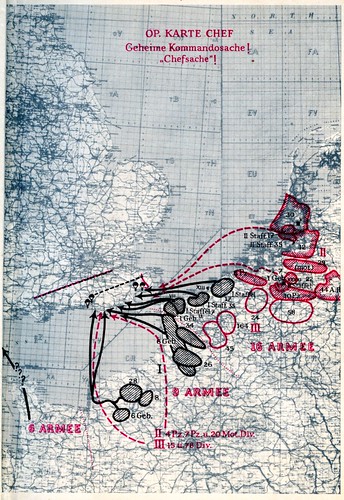
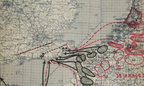
Maps for Seelöwe
Posted: Wed Jul 14, 2010 12:23 am
by Leandros
Would anybody happen to have a digital map set that covers Operation Seelöwe (Sea Lion) - the planned invasion of England Fall 1940? Would be grateful for any assistance.
Re: Maps for Seelöwe
Posted: Wed Jul 28, 2010 9:30 am
by Abicht
I am sure these maps exist somewhere, but I have never come across original color maps.
Re: Maps for Seelöwe
Posted: Wed Jul 28, 2010 2:45 pm
by phylo_roadking
Re: Maps for Seelöwe
Posted: Thu Jul 29, 2010 12:20 am
by Leo Niehorster
Good links.
Thanks.
Leo
Re: Maps for Seelöwe
Posted: Sun Feb 27, 2011 11:55 am
by Florin
My personal opinion: if the invasion would be attempted in June-July 1940, BEFORE making sure that the Royal Air Force was terminated, it would succeed in geting a bridgehead in the south of England. The British battleships coming from Scotland would be vulnerable to aerial attacks and submarines.
Re: Maps for Seelöwe
Posted: Tue Mar 08, 2011 9:59 am
by Leandros
Florin wrote:My personal opinion: if the invasion would be attempted in June-July 1940, BEFORE making sure that the Royal Air Force was terminated, it would succeed in geting a bridgehead in the south of England. The British battleships coming from Scotland would be vulnerable to aerial attacks and submarines.
Whatever time the Sea Lion would have gone in I do not believe the Admiralty considered to send their large ships to the vicinity of the Channel. Too close to the main German bomber forces.
Re: Maps for Seelöwe
Posted: Wed Mar 09, 2011 6:11 am
by lwd
My impression is that they were considered to be unnecessary given the expected German naval presence. If they were judged to be necessary I strongly suspect that they would have made their presence known. Indeed didn't the Sandhurst game assume they showed up at something like D-Day plus 10?
Re: Maps for Seelöwe
Posted: Wed Mar 09, 2011 10:31 pm
by Florin
What happened on 10 December 1941 off the east coast of Malaya, near Kuantan, the capital of Pahang, would have happened 17 months earlier off the coast of Dover.
Re: Maps for Seelöwe
Posted: Thu Mar 10, 2011 9:56 am
by phylo_roadking
Despite the Sandhurst Games - Forbes never intended to send the Home Fleet further south than Great Yarmouth, and steadfastly refused for the fleet to exercise with the Army and practice
ground directed fire support from the sea. The Channel's various obstacles - many,
many sandbars and shallows....and BOTH sides' minefields - prevented the Home Fleet operating there.
Instead - the RN formed three 12 -destroyer-strong anti-invasion flotillas based at Chatham, Portsmouth and SOuthampton, each with a cruiser flagship; in edition, there were 350-400 coastal craft of the RN....and the 600 armed yatchs and fishingboats of the Auxiliary Patrol along the South Coast - these latter many hundreds of smaller, lighter armed vessels were of shallow enough draft to operate IN the Royal Navy's Channel minefields

The KM on the other hand could muster in the late summer of 1940 exactly FOUR larger surface units - two of them obsolete - less than ten destoryers, and 80-90 coastal craft - to both hold off the Home Fleet IN the North Sea....and to protect the invasion fleet in the Channel.
The Uboat fleet was questionable IN the Channel for the same reasons - shallows, sandbars, the reconstruction of the WWI-style Dover Mine Barrage....and the fact that after the Armistice with France, the majority of the submarine fleet needed major repairs and reconditioning; they'd been at sea almost constantly since the 1st of September 1939...
Re: Maps for Seelöwe
Posted: Thu Mar 10, 2011 10:37 am
by phylo_roadking
As for Malaya - that was one particular set of circumstamces; however, the OTHER aspect of this is the high level of cocnentrated air attack the RN was able to stand off when operating off Norway from April to June 1940
Only a handful of ships were ever hit, and few lost, to air attack...
And in the Channel the RN would be operating under air cover provided by the RAF; an ongoing air superiority battle overhead would at least mean that bombers were A/ busy elsewhere, and B/ couldn't operate in THAT environment against shipping below.
Re: Maps for Seelöwe
Posted: Thu Mar 10, 2011 1:40 pm
by lwd
phylo_roadking wrote:Despite the Sandhurst Games - Forbes never intended to send the Home Fleet further south than Great Yarmouth, and steadfastly refused for the fleet to exercise with the Army and practice
ground directed fire support from the sea. The Channel's various obstacles - many,
many sandbars and shallows....and BOTH sides' minefields - prevented the Home Fleet operating there.
Instead - the RN formed three 12 -destroyer-strong anti-invasion flotillas based at Chatham, Portsmouth and SOuthampton, each with a cruiser flagship; in edition, there were 350-400 coastal craft of the RN....and the 600 armed yatchs and fishingboats of the Auxiliary Patrol along the South Coast - these latter many hundreds of smaller, lighter armed vessels were of shallow enough draft to operate IN the Royal Navy's Channel minefields
...
Indeed I perhaps should have emphasised or expanded on why it was considered unnecessary and indeed potentially wasteful. British light units were more than up to the task.
AS for the KM heavy units
http://www.axishistory.com/index.php?id=1145 lists 3 light cruisers, Scheer, Hipper, and a couple of predreadnaughts. The KM had however ruled out using the predreadnaughts and the light cruisers acompanied by some liners got to play tag with home fleet.
Looking at
http://www.german-navy.de/kriegsmarine/ships/index.html
and inparticular:
http://www.german-navy.de/kriegsmarine/ ... tions.html
Sheer is conducting trials during most of this period and so not likely available and
Hipper comes out of the repair yard in early September and suffers an engine failure in late September that puts her back in the yard until the end of October. Since her role was planned to be a sortie if it comes off she is unlikely to survive the engine failure.
Note none of the above were actually planned to acompany, escort, or support the invasion fleet directly.
Re: Maps for Seelöwe
Posted: Thu Mar 10, 2011 1:43 pm
by lwd
Florin wrote:What happened on 10 December 1941 off the east coast of Malaya, near Kuantan, the capital of Pahang, would have happened 17 months earlier off the coast of Dover.
As a previous poster has suggested very unlikely. For instance how many squadrons of torpedo bombers did the LW have? How many squadrons trained in naval attack? Also note the losses inflicted on the LW during this period on slow unarmed or barely armed merchants. Then there's the over tasking of the LW in general ....
Re: Maps for Seelöwe
Posted: Thu Mar 10, 2011 1:48 pm
by phylo_roadking
AS for the KM heavy units
http://www.axishistory.com/index.php?id=1145 lists 3 light cruisers, Scheer, Hipper, and a couple of predreadnaughts. The KM had however ruled out using the predreadnaughts and the light cruisers acompanied by some liners got to play tag with home fleet.
The predereadnoughts certainly....and several of the others almost certainly...were combed out of men, stripped of crews almost entirely, to provide KM handling crews for the barges and freighters in the invasion fleet. Lutjens foresaw this as a major issue when it was proposed to sail the two predreadnoughts to England and ground them in sight of the invasion beaches to act as artillery support....!
Re: Maps for Seelöwe
Posted: Thu Mar 10, 2011 3:39 pm
by Florin
lwd wrote: ....................
Looking at
http://www.german-navy.de/kriegsmarine/ships/index.html
and inparticular:
http://www.german-navy.de/kriegsmarine/ ... tions.html
Sheer is conducting trials during most of this period and so not likely available and
Hipper comes out of the repair yard in early September and suffers an engine failure in late September that puts her back in the yard until the end of October. Since her role was planned to be a sortie if it comes off she is unlikely to survive the engine failure.
Note none of the above were actually planned to acompany, escort, or support the invasion fleet directly.
You are mentioning September, October... If there was ever an excellent moment to invade Great Britain, it was in June or July.
After that, forget about it.
Re: Maps for Seelöwe
Posted: Thu Mar 10, 2011 6:01 pm
by phylo_roadking
You are mentioning September, October... If there was ever an excellent moment to invade Great Britain, it was in June or July.
unfortunately....
1/ that wasn't the plan; even for the mid-September jumpoff or "three-day readiness order" the shipping wasn't gathered or ready; when Halder visited the Channel Ports at the start of September, the KM had repaired NONE of the heavy cranes etc. that they said were "necessary" for loading shipping, and various harbour basins were still full of sunken ships. The FJ wasn't ready for most of the time...even the September date was dubious for them due to a general lack in parachute silk, a lack of trained dispatchers due to the losses in Holland, the general loss of about 3/5s of the LW's Ju52s,etc. Even Goering's first date for starting the "true" (the LW's) Battle of Britain was originally only the 5th of August (delayed to the 12th for the first heavy raids due to the weather) - he didn't even START planning it until the 19th of July IIRC.
2/ in THAT initial six-eight week period,
Hitler was fastened on all his psi war ops, offers of peace, waiting for an expected coup in London etc., etc.. Directive 16 was his
giving-up on all that....as late as the 16th of July.